
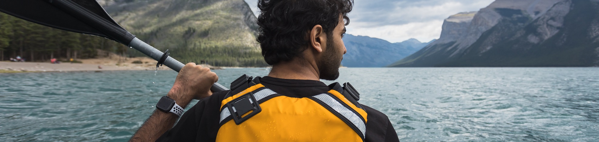
The park's mountain lakes and rivers provide easy flat water to advanced whitewater, and almost everything in-between. Rowboats, canoes, kayaks, sailboats, and other non-motorized boats are allowed on all lakes and rivers in the park. Boats with motors, both gas and electric, are restricted to Lake Minnewanka only.
Important information
Rules and regulations
An AIS Prevention Self-certification Permit or Parks Canada AIS Prevention Inspection permit is required for all non-motorized watercraft and water-related gear (e.g., canoes, kayaks, stand up paddle boards, fishing gear). The Self-certification Permit requires mandatory clean, drain, dry of all non-motorized watercraft and water-related gear, and attestation to these actions. Permits will be available online and at visitor centres and self-serve kiosks at waterbodies in Banff, Yoho and Kootenay national parks, or at Parks Canada watercraft inspection stations in Banff National Park.
Non-motorized watercraft and water-related gear users that do not meet Self-certification Permit requirements, but still wish to use their equipment within a park should visit a Parks Canada watercraft inspection station. Inspections and issue of a Parks Canada Inspection Permit will occur on a case-by-case basis at the discretion of inspectors.
Dry time requirements - Parks Canada Self-certification and Inspection Permits will require watercraft that has travelled outside of BC, AB, Yukon and Northwest Territories to dry for 30 days and those travelling within BC, AB, Yukon and Northwest Territories to dry for 48 hours.
More on aquatic invasive species rules and regulationsRiver hazards
The Bow River is a dynamic watercourse, continuously undergoing change. Erosion by swiftly flowing water can result in new channels, sweepers, and logjams developing overnight, creating deadly hazards in previously harmless locations. Paddlers must be constantly aware of the potential for danger at every bend of the river. These rivers demand that paddlers have precise control and the skills to perform tight maneuvering. Paddlers must be prepared and able to carry out rescue efforts for their group. You are in a remote area and in the case of an accident there will be significant delay before park rescuers will be able to get to you.
Hazards tend to develop at tight bends in the river, where flow is constricted and the current is strongest. On the outside of the curves, trees become undercut and fall into the river forming sweepers and strainers. Every curve in this section of river has the potential to develop these dangerous sweepers and strainers. Approach each bend in the river with caution, and stay to the inside of the curve where the current is slowest.
Logjams are a very dangerous form of strainer. These develop when sweepers wash into the river, float downstream, and become caught on the upstream points of islands and gravel bars, and at the entrances to small channels. Logjams can become very large, creating long term river hazards. Canoes coming onto sweepers or logjams can quickly capsize. The force of the current then pushes the canoe and the paddlers into, and often under, the strainer. If you hit a strainer, make all effort to come out on top of the snags. If you capsize, be prepared to abandon your canoe and gear until you are safely out of the water.
The danger of all the river hazards is magnified as the volume of the water increases. The higher the water level, the more powerful the flow, and the more dangerous is every sweeper and strainer on the river. All hazards are most deadly during spring run-off.
Safety
- Choose a trip suitable for your level of experience and current conditions such as weather and water levels.
- There are several guidebooks and how-to books on canoeing available in the bookstores in Banff.
- Limited route information is available at park information centres.
- Changing river levels, fast flow, sweepers, heavily wooded undercut banks, and shifting gravel bars mean that the location of hazards is unpredictable.
- River water contains glacial silt, fecal streptococci or giardia, so it should be filtered and then treated or boiled before drinking or bring along your own drinking water.
- Water temperature seldom rises above 10° C (50° F). A capsize in these chilly waters can result in hypothermia. Read up on hypothermia and how to treat it, before you set out.
- Leave word of your plans and when you expect to return.
What to Bring
- Take along wet weather gear to keep you dry, warm and to protect you from the wind.
- Carry a complete change of clothing, just in case you fall in.
- For whitewater trips wear a wetsuit or drysuit and wetsuit boots or neoprene socks with runners.
- Use a waterproof bag or double bag your gear in two heavy-duty plastic garbage bags (sealed individually), to keep spare clothing and gear dry.
- Carry waterproof matches in a waterproof case, as well as rescue gear such as a throw bag, a saw and a first aid kit.
Camping
Paddlers must camp at designated roadside or backcountry campgrounds. The only camping along the Bow River is at the backcountry campground Bo1C (river access-only), at Johnston Creek. Fires are allowed in the designated fire pits only. A Backcountry Use and Camping Pass is required for any overnight stays in the backcountry.
| Lakes | ||||
|---|---|---|---|---|
| Banff area |
|
|
|
|
| Lake Louise area |
|
|
||
| Icefields Parkway |
|
|
|
|
Wind warning: Beware of the very sudden strong winds and waves on big lakes such as Lake Minnewanka and Hector Lake; especially in the afternoon.
Rivers
The Bow River in Banff National Park provides some excellent canoeing opportunities for experienced canoeists.
The three most popular sections for canoeing are described here:
Section #1: Lake Louise to Castle Junction
Distance: 22 km
Duration: 3 - 4 hours
Difficulty: intermediate
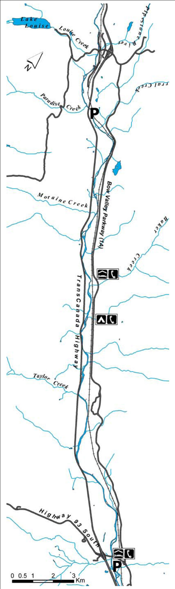
This section of the Bow River begins downstream of the village of Lake Louise. It is sandwiched between the Trans-Canada Highway on the west side, and the Canadian Pacific Railway line and Highway 1A (Bow Valley Parkway) on the east side. The Bow River flows with a steady current as it winds its way down the valley. There are numerous riffles and Class 1 rapids. You may encounter sweepers and logjams. Although this section contains many islands and side channels, route finding is straightforward.
Starting at Lake Louise: The put-in is at a small side channel approximately 750 metres east of the Trans-Canada Highway bridge over the Bow River, east of the village of Lake Louise. There is a service road turnoff into a meadow. Do not block the road when you park your car.
This small channel flows back into the main river in about 100 metres. The first 3 kilometres of river to the Moraine Creek viewpoint provides some fast water and tight corners which may require precise maneuvering. At the viewpoint, another continuous section of swift water, waves, and tight bend begins. These are high-risk areas and should be approached with caution and scouted for hazards.
The next landmark is the confluence with Baker Creek on river left, approximately 5 km downstream from Moraine Creek. From this point, the river slows somewhat and the current is more consistent. For the next 14.5 km, the river winds its way down the valley below the cliffs of Castle Mountain. This brings you to the end of this section at the bridge at Castle Junction. Take out on river left at the parking lot just downstream of the bridge.
In case of emergency
There is no direct access to the river from the east side, although you can easily hike out to Highway 1 or 1A just about anywhere if necessary. There are telephones on the east side of the river at Baker Creek Bungalows, Protection Mountain Campground and Castle Mountain Village at Castle Junction.Section #2: Castle Junction to Banff
Distance: 32 km
Duration: 5 - 6 hours
Difficulty: intermediate
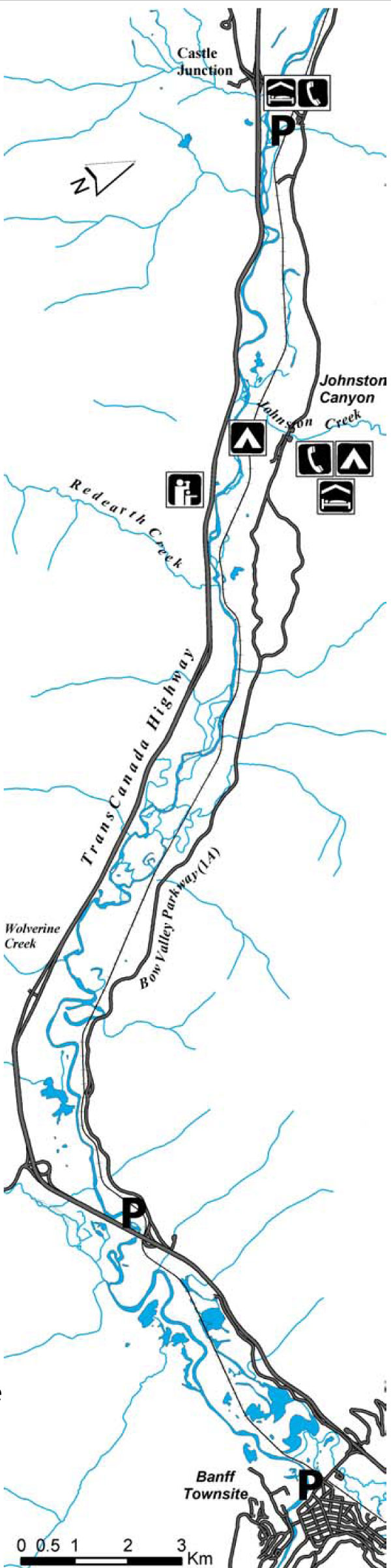
This section of the Bow River is bounded on the west side by the Trans-Canada Highway. On the east side is the Canadian Pacific Railway line and Highway 1A (Bow Valley Parkway). The Bow River flows with a steady current as it winds its way down the valley, with many islands and interesting side channels to explore. There are numerous riffles, and Class 1 rapids, with one Class 3 rapid at Redearth Creek. Tight corners, sweepers and logjams are common, especially for a section downstream of Redearth Creek. You need to take extra care in maneuvering your canoe here.
Starting at Castle Junction. The put-in is at the parking lot on the downstream side of the bridge over the Bow River at Castle Junction. Six km of winding river brings you to the confluence with Johnston Creek, flowing in from river left. Just on the downstream side of Johnston Creek there is a sign for the backcountry campsite. 3 km past Johnston Creek, a right bend in the river leads you towards the Trans-Canada Highway and the Castle Mountain Viewpoint.
This is an important landmark as it indicates that you are approaching Redearth Creek Rapids. As you paddle below the viewpoint, the river makes a left bend away from the highway. In just a couple of hundred metres, the river makes a sharp right turn into the area of Redearth Creek Rapids. Red Earth Creek Rapid, rated Class 3, is a long section of fast water and rocks. The waves are continuous, getting bigger and bigger as you approach the end. Many canoes have capsized or swamped here. With proper scouting and safety procedures, this rapid can be run by experienced canoeists.
If you want to portage the rapid you will have to find your own route as there is no specific portage route. From the top of the rapid on river right, make your way along the shore to where Redearth Creek enters the Bow River. Wade across the creek and carry your canoe along the riverside trail to the end of the rapids.
A couple of kilometres below Redearth Creek, the river becomes very convoluted. It may not be readily apparent, but the river actually branches into two or three channels. This is an exceptionally risky section, with very tight corners, dangerous logjams, and endless sweepers. Vigilance is imperative here.
The large gravel fan at the entrance of Wolverine Creek on river right, marks the end of the major hazards along this section. Another 5.5 km brings you back to the Trans-Canada Highway. This is a good place to take out as there is a gate through the fence to access a roadside parking area off the westbound lane of the highway.
Another 0.5 km brings you to the Trans-Canada Highway bridge over the Bow River. Take care passing under the bridge as there are many sweepers along the left side of the river. From here to Banff is a pleasant, 1.5 - 2 hour paddle. The river is broad and calm, allowing beautiful views of the lower Bow Valley. Take out at the canoe docks, at the junction of the Bow River and Echo Creek. Do not paddle past the canoe docks as Bow Falls is just around the corner.
In case of emergency
Although you can hike out to Highway 1 or 1A in many places if you have an emergency, there are numerous side channels and swampy areas in this section that can make walking difficult. There is a telephone on the east side of the river on Hwy 1A at Johnston Creek.Section #3: Bow Falls to Canmore
Distance: 23 km
Duration: 4 hours
Difficulty: intermediate
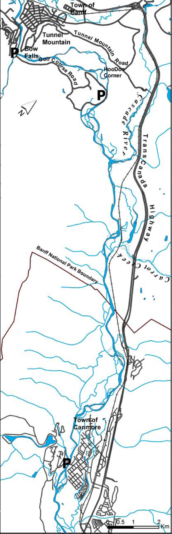
This scenic section starts downstream of Bow Falls and winds beneath the shadow of Mount Rundle to Canmore. You can start at either the Bow Falls parking lot, or from the east end of the Golf Course Road. Do not block any roads when parking.
1. Starting at Bow Falls
Paddling this section, the main channel is generally to the right. Smaller channels on river left can be run by canoes at higher water levels. But, all side channels are smaller, with difficult tight turns and are more likely to be blocked by dangerous sweepers and logjams. As you approach the end of the golf course and can see the glacial till pinnacles of the Hoodoos just ahead, the river makes several tight bends and corners. All channels here have sweepers and strainers in them and canoeists should exercise extreme caution.
2. Starting at the end of the golf course
Within minutes of launching or passing this site, the river forks. The channel on river right is the safest route. The channel on river left leads to a dangerous strainer logjam that completely blocks the entrance to a small channel. From this point on, the river is generally wide, as it flows along the base of incredible Mount Rundle. As you approach the confluence of Cascade River, the river widens and braided channels and gravel bars appear. Care must be taken, as numerous channels are available, with the possibility of sweepers and logjams in all of them. After the park boundary (a small sign is found on the river right bank) the river becomes narrower again, with tight corners and numerous sweepers and strainers. This area demands precise control and maneuvering and canoeists are advised to proceed with extra caution.
Getting off the river:
On river left at the park boundary, a trail leads for 200 metres to the highway at the park gates. In Canmore, take out on river right, just downstream of the first pedestrian bridge.
In case of emergency
There is a trail near the river on the right that connects the Banff Springs Golf Course to the Canmore Nordic Centre. Subchannels or swampy valley bottom may block access to the Trans-Canada Highway on the left. The shortest way out for help may be to follow the railway tracks towards Canmore, or to flag a passing canoe or raft.Printable version (PDF, 515 kb)
- Date modified :