
Fundy's trail network
Fundy National Park
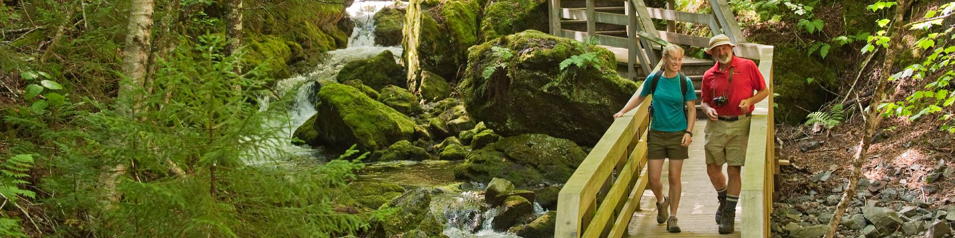
Fundy National Park has a large trail system with soaring coastal views showcasing the highest tides in the world and the Acadian forest. Come marvel at the waterfalls, descend into moss-covered river valleys and swim in backcountry pools. If you're lucky, you may even see some of New Brunswick's wildlife! Our trails ranking uses the international system, so you can be sure you know what you are getting into.
You can contact the Visitor Centre or check out trail conditions for the most up to date information.
Trans Canada Trail
Discover the world's longest network of recreational trails and enjoy more than 27,000 km of beauty. The Trans Canada Trail winds through every province and territory in the country and connects visitors to Canada's spectacular natural and cultural heritage.
Trail list
Below is the complete list of all hiking and mountain biking trails in Fundy National Park.
| Name | Distance/Time | Habitats | Features | ||||||||
|---|---|---|---|---|---|---|---|---|---|---|---|
| Easy trails These trails are somewhat flat and have a hard packed surface. They are suitable for all visitors, regardless of hiking experience. Fundy also has some trails that are wheelchair accessible. |
|||||||||||
| MacLaren Pond Medicine Trail | 1 km return trip 30 min |
Frogs, dragonflies and beavers |


|
||||||||
| Alma Beach | 100 metres 10 min |
Beach access, tidal viewing point |


|
||||||||
| Caribou Plain | 2.1 km loop 1 to 1.5 h |
Carnivorous bog plants, beaver ponds |


|
||||||||
Shiphaven |
1 km return trip 30 min |
Magnificent estuary views, covered bridge |

|
||||||||
| Cygnus | 1.5 km one way 15 to 20 min |
Forest |

|
||||||||
| Cassiopeia | 0.9 km one way 15 min |
Forest |
|
||||||||
| Ursa Major | 1 km one way 15 to 20 min |
Forest |
|
||||||||
| Ursa Minor | 0.7 km one way 15 min |
Forest |
|
||||||||
| Orion | 1 km one way 15 to 20 min |
Forest |
|
||||||||
| Moderate trails Moderate trails will have some elevation gain with short steep sections. We recommend that you have some basic hiking experience for these hikes. |
|||||||||||
| East Branch | 5.6 km loop 2 to 2.5 h |
Forest |
|
||||||||
| Kinnie Brook | 2.8 km return trip 1.5 h |
Steep walled valley, disappearing stream. |

|
||||||||
| Matthews Head | 4.5 km loop 1.5 to 2 h |
Great coastal views, sea stack |
|
||||||||
| Coppermine | 4.4 km loop 1.5 to 2 h |
Old mine site, great coastal views |
|
||||||||
| Dickson Falls | 1.5 km loop 30 to 45 min |
Boardwalk and stairs, tumbling cascades |


|
||||||||
| Herring Cove Beach | 1 km return trip 30 min |
Beach access, stairs |


|
||||||||
| Black Horse | 4.4 km loop 1.5 to 2 h |
Former homestead foundations, view of Bay |
|
||||||||
| Maple Grove | 3.5 km one way 1.5 to 2 h |
Open hardwood forest, beautiful fall colours |
|
||||||||
| Peregrine | 1 km one way 15 to 20 min |
Forest |
|
||||||||
| Pumptrack | 106.5 m and 141.6 m loops | Forest |
|
||||||||
| Dobson Link |
2.6 km one way 1 to 1.5 h |
Forest fire regeneration |
|
||||||||
| Laverty Falls | 2.5 km one way 1 to 1.5 h |
Curtain waterfall, swimming hole. |

|
||||||||
| Tracey Lake | 7 km one way 2.5 h |
Trail can be wet, moose and pitcher plants |

|
||||||||
| Difficult trails Difficult trails can have lots of elevation gain, be steep or even have obstacles. These trails are for visitors who have hiking experience. Please come prepared with the proper equipment. |
|||||||||||
| Third Vault Falls | 7.4 km return trip 3 to 4 h |
Park's highest waterfall (16 m) |
|
||||||||
| Coastal East |
3 km one way 2 h |
Ridge top views, fern glades, lush forests |

|
||||||||
| Coastal West |
6.7 km one way 2.5 to 3 h |
Steep sections, coastal views |
|
||||||||
| Goose River |
11.3 km one way 2.5 to 3 h |
Spectacular backcountry camping |
|
||||||||
| Bennett Brook | 13 km return trip 5 to 6 h |
Dam and fishway, steep switchback climbs |
|
||||||||
| Marven Lake | 8.5 km one way 2.5 to 3 h |
Home to trout, bullfrogs, moose and beaver |
|
||||||||
| Whitetail | 5.7 km one way 2 to 2.5 h |
Mountain biking, several small brook crossings |
|
||||||||
| Tippen Lot North | 3 km one way 1.5 to 2 h |
Beech grove |
|
||||||||
| Foster Brook | 4.4 km one way 1.5 to 2 h |
Shaded forest, unique backcountry camping |
|
||||||||
| Moosehorn |
4.5 km one way 2 to 3 h |
Steep descent and return, great picnicking |
|
||||||||
| The Forks |
3.2 km one way 1.5 to 2 h |
Steep descent and return, deep pools |
|
||||||||
| Tippen Lot South | 1.85 km one way 1.5 to 2 h |
Old beaver pond, panoramic view of the forest |
|
||||||||
| Upper Salmon River |
8.2 km one way 3.5 h |
Salmon pools, rapids and river crossing |
|
||||||||
We recommend submiting a trip plan using AdventureSmart and someone will check to make sure you arrive safe.
- Date modified :